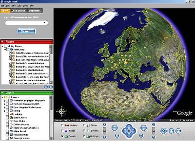
 The start-up screen. At left is a list of interesting places, and options that allow you to choose
if you also want to see borders, volcanos, grocerie stores and so on.
The start-up screen. At left is a list of interesting places, and options that allow you to choose
if you also want to see borders, volcanos, grocerie stores and so on.
Below the map window is a list of controls, which I hardly ever use, as I run the program with the mouse buttons and the mouse wheel alone.
 If you like a place, you can stick a pin on the map to help you find it again. Thats what I did, marking all
the poster places where I had been (or would like to go).
If you like a place, you can stick a pin on the map to help you find it again. Thats what I did, marking all
the poster places where I had been (or would like to go).
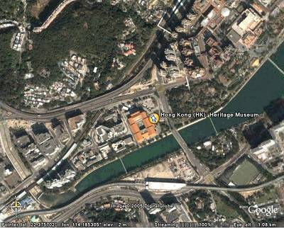 And then you turn the globe around until you see China, and zoom in closer until you see Hong Kong,
and closer until you see the Heritage Museum,
location of the Hong Kong International Poster Triennials.
And then you turn the globe around until you see China, and zoom in closer until you see Hong Kong,
and closer until you see the Heritage Museum,
location of the Hong Kong International Poster Triennials.
Actually, I'm not that familiar with Hong Kong, but I had my GPS with me last year when Jianping He and our friends from Shenzhen took me there and I measured the coordinates of the front entrance, and so I simply entered them into Google Earth to find my way back to museum again.
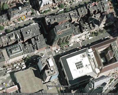 You can zoom in even closer until you see the cars on the streets, as in this view near the
International Poster
Gallery in Boston MA (US). Not all places on earth can be seen with such high resolution, but I am
confident that this is just a matter of time.
You can zoom in even closer until you see the cars on the streets, as in this view near the
International Poster
Gallery in Boston MA (US). Not all places on earth can be seen with such high resolution, but I am
confident that this is just a matter of time.
I have never been there, but found the place from a Boston city map and the street address.
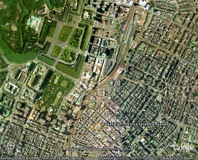 Sometimes, it is interesting to fly a little higher, 2340 meters high in this view of the
GGG Gallery in Tokyo.
Then you realize that the Imperial Palace, in the green park at upper left, is just around the corner.
Sometimes, it is interesting to fly a little higher, 2340 meters high in this view of the
GGG Gallery in Tokyo.
Then you realize that the Imperial Palace, in the green park at upper left, is just around the corner.
Ah, to be the Emperor of Japan!
 You can also fly in tilt mode and see the scenery at various angles. Flying through Grand Canyon is an experience that
is hard to beat, but Echirolles in the french alps and home of the
Mois du Graphisme d'Echirolles is not so bad
either from the air. I exaggerated the altitude representation a bit.
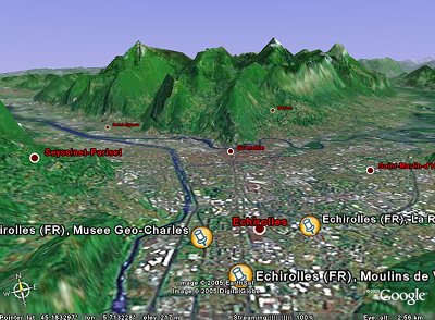
You can also fly in tilt mode and see the scenery at various angles. Flying through Grand Canyon is an experience that
is hard to beat, but Echirolles in the french alps and home of the
Mois du Graphisme d'Echirolles is not so bad
either from the air. I exaggerated the altitude representation a bit.
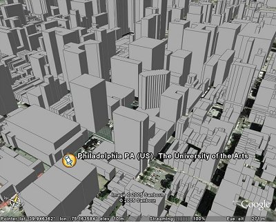 For some US cities, the height of each building is also stored, which allows a 3-D view of a city,
from all possible angles. This is The University of the Arts in Philadelphia PA (US), where Philippe Apeloig recently had
an exhibition.
For some US cities, the height of each building is also stored, which allows a 3-D view of a city,
from all possible angles. This is The University of the Arts in Philadelphia PA (US), where Philippe Apeloig recently had
an exhibition.
The pin appears to bu stuck to the wrong building, but it marks the entrance to the building just to its left, and would be hidden if it were at ground level.
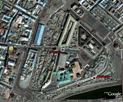 Finally, some nostalgic pictures, for me: This is the
Russian State Library in Moscow,
the former Lenin Library, that is said to hold over 400 ' 000 posters in it's collection. The Kremlin,
and the Red Square (actually gray and rectangular) is to the upper right.
Finally, some nostalgic pictures, for me: This is the
Russian State Library in Moscow,
the former Lenin Library, that is said to hold over 400 ' 000 posters in it's collection. The Kremlin,
and the Red Square (actually gray and rectangular) is to the upper right.
When I visited the library in 1994 together with my daughter, then still a student, we had a problem at first: It had segregated reading rooms! The one for students had hard seats and long delays when ordering books, the other one for doctors had flowers on the tables and pretty lamps. Some call that "social realism". Russian hospitality prevailed over bureaucracy however, and we were allowed to study russian poster books side by side, on soft chairs.
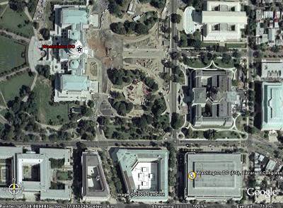 The counter part, the huge
Library of Congress in Washington DC, is equally close to the
centers of power, but more egalitarian. Everybody, whether czar or peasant, had to refill the paper himself
in the printers of the catalogue room. The Capitol building is at upper left.
The counter part, the huge
Library of Congress in Washington DC, is equally close to the
centers of power, but more egalitarian. Everybody, whether czar or peasant, had to refill the paper himself
in the printers of the catalogue room. The Capitol building is at upper left.
I was told there, in 1989, how the Gary Yanker political poster collection was digitized in a pioneering effort, at enormous costs, long before the internet, before jpgs and CDs, cheap scanners and digital cameras. We have come a long way.
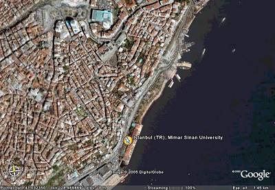 Mimar Sinan University in Istanbul, Turkey, home of the annual Grafist International Design weeks organized by Sadik Karamustafa.
How they ever can get the students to work at such a beautiful seaside location is a mystery to me.
Mimar Sinan University in Istanbul, Turkey, home of the annual Grafist International Design weeks organized by Sadik Karamustafa.
How they ever can get the students to work at such a beautiful seaside location is a mystery to me.
The list of places is on my page about GPS coordinates of interesting poster places .
There is a "Play Tour" button (F10) which automatically flies you from place to place. As the places are ordered alphabetically, starting in Albi, France, with the Musee Toulouse-Lautrec, and ending in Washington DC with the Library of Congress, passing Kharkov, Ukraine, on the way, this will be quite a world trip, taking only a few minutes however.
Remember that Google Earth is currently a beta version. Some people that I asked to test the m001.kmz link reported succes, with others it did not work at all. If you have a PC, download Google Earth yourself, if you have a Mac be patient.